KONTAKT
email:[zasłonięte]@op.plnr tel: +486[zasłonięte]14561
WYSYŁKA
Wysyłka standardowa firmą:
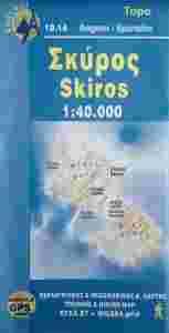
| SKIROS/SKYROS/SPORADY WYSPY GRECJA MAPA 1:20 000 ANAVASI
Skala: 1:40 000
Oprawa: miękka
Format: 22.4 x 11.4
Data wydania: 2006
ISBN: 978-[zasłonięte]-8195-837 EAN: 978[zasłonięte][zasłonięte]81958 Język: grecki angielski francuski niemiecki włoski
OPIS:
Wydawnictwo ANAVASI powstało w Grecji w 1997 roku i dzisiaj oferuje ponad 100 różnych tytułów map w róznych skalach.
Dobrze znane greckie wydawnictwo kartograficzne ANAVASI specjalizuje sie w wysokiej jakości mapach turystycznych regionów, parków narodowych i wysp greckich.
Mapy tego wydawnictwa cechują sie bogactwem i rzetelnością informacji.
More exposed to the winds of the Aegean and less to those that swept away the popular cultures, Skyros is like an ark. Indeed, beside the embroidery, the wood carving, the ceramics, the mettalurgy, the aesthetics and functionality of the Skyrian home, the island has preserved a rare race of small-sized horse which roam on the quiet mountain sides. The land of Skyros is divided in two parts: the rough and uninhabited south, named Vouno and the mild and green north, the Meroi. There are hikes on both parts: those of the Meroi run through forested or cultivated land, lead to chapels or nice beaches, while those of Vouno, have a mountain "ambiance" and nice views. The map comprises a sketch with 10 proposed hikes.
|