TEL: 607-[zasłonięte]-671
GG: [zasłonięte]16851
EMAIL: [zasłonięte]@bookstreet.pl |
|
Kupując kilka książek za wysyłkę płacisz tylko raz!
Do realizacji zamówienia przystępujemy po otrzymaniu zapłaty za towar lub wybraniu opcji przesyłki za pobraniem. Książki wysyłamy w ciągu 5-7 dni roboczych, nie ma możliwości szybszej realizacji.
Wystawiamy faktury VAT.
|
|
|
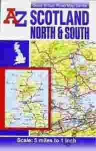
Scotland Road Map (reversible) (A-Z Road Maps & Atlases)
|
|
PRODUCT DETAILS:
Language: English
Publisher: Geographers A-Z Map Company
Publication Date: 18 Oct 2010
Dimensions: 23.1 x 14.5 x 0.5 cm
Format: Paperback
Pages: 1
Condition: NEW
Product_ID: 1D4C4D6296
|
This full colour double sided foldout sheet map of Scotland is one of a series of five maps covering Great Britain, with a continuous grid referencing system which enables several or all of the sheets to be mounted together, whilst retaining the compatibility of the index.
- The Northern Scotland map covers the mainland of northern Scotland from Oban and Perth in the south to Cape Wrath and John o' Groats in the north. and includes the Isle of Sky, the Inner Hebrides and the Western Isles. The Orkney and Shetland Islands are featured in an inset map at a scale of approximately 12.5 inches to 1 mile.
- The Southern Scotland map covers the remainder of Scotland southwards to include a large section of Northern England which includes Berwick-upon-Tweed, Newcastle-upon-Tyne, Middlesbrough, York, Skipton, Fleetwood, Whitehaven and Carlisle. The Isle of Man and part of Northern Ireland are also covered.
The map information includes motorways open with full junction detail, motorways under construction and proposed, service areas, primary routes and destinations, A and B roads, gradients 1:5 and steeper, tolls, mileages, national and county boundaries, spot heights and hill shading. A wide range of places of interest, tourist and ancillary information sites are included on the mapping.
Attached to the cover is an index booklet which lists cities, towns, villages, hamlets and locations covered by the mapping.
|
Książki wysyłamy w ciągu 5-7 dni roboczych.
|