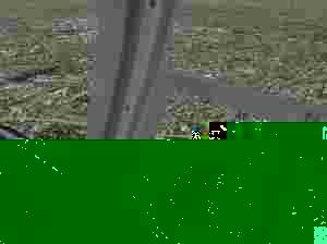
When pilots fly cross-country they use a range of landmarks on the ground to help them find their way and pinpoint their position. The most distinctive of these are roads, rivers and coastlines, but in FlightSimulator 2004 these simply aren't reproduced accurately enough to allow them to be used for navigation. All this is about to change thanks to Roads Rivers of Europe, which updates the default scenery of Europe with a set of accurately placed roads, rivers coastlines that are positioned to within 15 metres of the real thing.
Using high-quality in-car NAVTEQ GPS navigation data, Roads Rivers of Europe maps major and minor roads as well as motorways, autoroutes and autobahns. The accuracy doesn't stop with tarmac -all the major rivers, inlets and coastlines are correctly positioned, while lakes and other water features missing from the default scenery are replaced.
Product Description
A unique expansion for the virtual pilot that puts the roads, rivers and coastlines of Europe in their proper place in Flight Simulator 2004. Using high-quality in-car NAVTEQ GPS navigation data, Roads & Rivers of Europe maps major and minor roads as well as motorways, autoroutes and autobahns. The accuracy doesn't stop with tarmac - all the major rivers, inlets and coastlines are also correctly positioned, while lakes and other water features missing from the default scenery are replaced. Virtual pilots can now find their way across Europe using the same important landmarks as their real-world counterparts. When pilots fly cross-country they use a range of landmarks on the ground to help them find their way and pinpoint their position. The most distinctive of these are roads, rivers and coastlines, but in Flight Simulator 2004 these simply aren't reproduced accurately enough to allow them to be used for navigation.All this is about to change thanks to Roads & Rivers of Europe, which updates the scenery of Europe with a set of accurately placed roads, rivers and coastlines that are positioned to within 15 metres of the real thing. Roads & Rivers of Europe covers the following countries: Austria, Belgium, Czech Republic, Denmark, Finland, France, Germany, Ireland, Italy, Luxembourg, The Netherlands, Norway, Spain, Sweden, Switzerland, Portugal and the United Kingdom Detailed and complex road intersections are modelled Main roads in cities are included The size of roads varies according to their real world classification Road bends and junctions accurately shown The course and size of major rivers are accurately depicted �
137[zasłonięte]4016 false -1 0 0 0(0)
- Kindle E-readers
-
Small, light, perfect for reading
-
Our most advanced e-reader
-
With free 3G wireless
-
Covers, chargers, sleeves and more
- Kindle Store
-
With Prime, Kindle device owners read for free
- Kindle Fire Tablets
-
7", The perfect family tablet
-
7", Stunning HD, Dolby Audio, Ultra-Fast Wi-Fi
-
8.9", Our highest resolution, largest HD display
-
Covers, chargers, stylus, audio and more
- Kindle Apps Resources
-
For PC, iPad, iPhone, Android, and more
- Appstore for Android
-
Kindle, mobile shopping, MP3, and more
-
View your apps and manage your devices
-
New customer?
-
Play from any browser
-
5 GB of free storage
Your Shopping Basket is empty.
Give it purpose -- fill it with books, DVDs, clothes, electronics and more.
If you already have an account, .
There's a problem previewing your shopping basket at the moment.
Check your Internet connection and , or .
After viewing product detail pages, look here to find an easy way to navigate back to pages you are interested in.
|
|
›
|
After viewing product detail pages, look here to find an easy way to navigate back to pages you are interested in.
|
|
›
|