| |
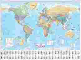
 Collins World Wall Laminated Map (World Map)
Language: English
Publisher: Collins
Publication Date: 20 Jun 2013
Dimensions: 138.4 x 101.6 cm
Format: Poster
Pages: 1
Condition: NEW
This laminated Collins World Map has been fully updated to include the latest political changes, and contains politically coloured mapping showing each country and their capital city, major roads, railways and cities and towns clearly. Also included are national flags, key statistics for every country and inset maps of the polar regions.
This laminated (on front side only) map is ideal for any classroom, bedroom or office wall.
INCLUDES:
• All recent political changes including the new independent country of South Sudan
• Changes to international dateline
AREA OF COVERAGE
All of the world, centred on the Greenwich Meridian, and including maps of the North and South Pole regions.
SCALE
1:22 [zasłonięte] 000, 1 cm to 220 km, 1 inch to 347 miles
SIZE
1015 x 1380 mm (40 x 54 inches)
OTHER VERSIONS AVAILABLE
Paper flat map in tube (ISBN 978-0-00-[zasłonięte]311-1).
ISBN: 978[zasłonięte][zasłonięte]74931
| | PROSZĘ ZAPOZNAĆ SIĘ Z WARUNKAMI AUKCJI PODANYMI NA DOLE STRONY ORAZ NA STRONIE O MNIE I W TREŚCI WIADOMOŚCI POTWIERDZAJĄCEJ ZAKUP W moim sklepie kupisz najtańsze w Polsce książki w języku angielskim. Jeśli jesteś zainteresowaniy jakąś pozycją, a nie posiadam jej aktualnie wystawionej - proszę o wiadomość - gwarantuję, że u mnie będzie najtaniej! Zapraszam na inne aukcje Wyszukiwanie za pomocją numeru ISBN: WYSZUKIWARKA ISBN JEŚLI ZNAJDZIESZ DANĄ POZYCJĘ TANIEJ U KOGOŚ NA ALLEGRO - PROSZĘ O INFORMACJĘ PRZED ZAKUPEM - U MNIE BĘDZIE JESZCZE TANIEJ! DO KAŻDEJ PRZESYŁKI PACZKĄ POCZTOWĄ LUB KURIEREM DOŁĄCZAM DARMOWĄ KSIĄŻKĘ UŻYWANĄ Z LISTY DOSTĘPNEJ NA STRONIE "O MNIE" Warunkiem otrzymania darmowej książki jest wpisanie jej numeru w formularzu dostawy. Zdjęcie poglądowe - okładki mogą się różnić. | |

