KONTAKT email:[zasłonięte]@op.plnr tel: +486[zasłonięte]14561 WYSYŁKA Wysyłka standardowa firmą:
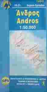
| ANDROS /CYKLADY/GRECJA MAPA 1: 50 000 ANAVASI
Skala: 1:50 000 Oprawa: miękka Format: 22.4 x 11.4 Data wydania: 2009 ISBN:978-[zasłonięte]-8195-745 EAN: 978[zasłonięte][zasłonięte]81957 Język: grecki angielski francuski niemiecki włoski
OPIS: Wydawnictwo ANAVASI powstało w Grecji w 1997 roku i dzisiaj oferuje ponad 100 różnych tytułów map w róznych skalach. Dobrze znane greckie wydawnictwo kartograficzne ANAVASI specjalizuje sie w wysokiej jakości mapach turystycznych regionów, parków narodowych i wysp greckich. Mapy tego wydawnictwa cechują sie bogactwem i rzetelnością informacji.
Andros is a large island (374 sq km or 147 sq miles), mountainous, with rich vegetation in several parts of the island and abundant running water, as testified by more than 150 watermills. A network of footpaths, many of them between dry-stone walls and several laid with large slate stones, criss-cross the island’s hinterland. Several paths are maintained and way-marked. Chora, the main settlement of Andros, has many neoclassical houses, an interesting archaeological museum, and a particularly active museum of modern art that hosts interesting exhibitions every year.
|